
Monday, July 27, 2009
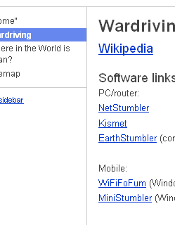
RYANMETCALF.NET Wardriving resource page
I'm currently transitioning my personal homepage for a bit to Google Sites, till I get things figured out/hosted elsewhere, but have a small (but growing) collection of resources and datafiles related to wardriving. http://www.ryanmetcalf.net/wardriving (or permanent link)
--Ryan
¶ 11:50 AM 0 comments

--Ryan
¶ 11:50 AM 0 comments
Wednesday, August 02, 2006
Largest KML yet!
As of now, we have 8593 points in our latest stumbler log, which has already been converted into a KML and is ready for download here: http://www.ryanmetcalf.net/downloads/kml/wardriving/master_kml/coverage_chart.kml (16 mb) we also have all of our other individual KML's (a lot smaller to dl, though some points will be duplicates in the small files. The earth logo below and the one above the posts will take you to our KML repository.

(just because we wardrive everywhere we go, there a quite a few hotspots from Lawrence, KS and St. louis, MO included in the KML file (s))
--Ryan ¶ 8:00 AM 0 comments
(just because we wardrive everywhere we go, there a quite a few hotspots from Lawrence, KS and St. louis, MO included in the KML file (s))
--Ryan ¶ 8:00 AM 0 comments
Monday, July 24, 2006
Indentifying Wireless connectors
After ordering a couple of different wireless connectors for my helical waveguide antenna project and not getting the right ones, I decided to get smart and use a guide located on the internet. The clip below highlights the type of connectors I have on my Linksys WRT54G (v1.1) wireless router.
Links:
Antenna connector guide article, http://wireless.gumph.org/content/3/7/011-cable-connectors.html
TNC Wikipedia aritcle, http://en.wikipedia.org/wiki/Threaded_Neill-Concelman_connector
SMA Wikipedia article, http://en.wikipedia.org/wiki/SMA_connector
--Ryan ¶ 8:00 PM 0 comments

 | 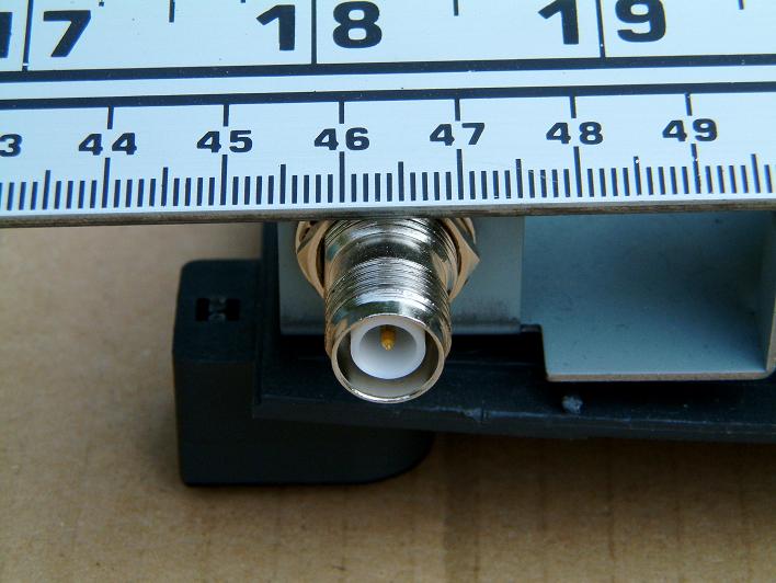 |
| Male RP-TNC | Female RP-TNC |
TNC connectors are usually found on access points such as the linksys WAP11. | |
Links:
Antenna connector guide article, http://wireless.gumph.org/content/3/7/011-cable-connectors.html
TNC Wikipedia aritcle, http://en.wikipedia.org/wiki/Threaded_Neill-Concelman_connector
SMA Wikipedia article, http://en.wikipedia.org/wiki/SMA_connector
--Ryan ¶ 8:00 PM 0 comments
Sunday, July 16, 2006
Wardriving Facebookers?
There's now a global group on facebook for all wardrivers. If your on facebook come join us!

Links:
Wardriving Facebook Group, http://facebook.com/group.php?gid=2204913027
--Ryan ¶ 4:00 PM 0 comments
Links:
Wardriving Facebook Group, http://facebook.com/group.php?gid=2204913027
--Ryan ¶ 4:00 PM 0 comments
Wednesday, July 12, 2006
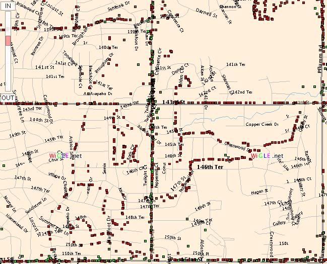
Wigle: It's for finding hotspots
So, if everyone's out there collecting all of this wardriving data, they have to be sharing it somewhere, where?
One of the sites that supports users to upload their netstumbler (and other sniffing tools) logs to is Wigle. Wigle then takes that data and compares it to their existing data, using it to correct existing hotspots and place new ones onto the map. You can perform searches by SSID, address, state, metro, etc.
Links:
The Wigle homepage, http://www.wigle.net
Kansas City metro area on Wigle maps ¶ 1:30 PM 0 comments
Tuesday, July 11, 2006
Converting Stumbler data into KML
In response to Kyle's post about converting kismet data into KML's for the Linux crowd, I thought I'd post up information for the windows/netstumbler crowd. Simpler then writing a conversion script, as is with the case of the kismet transfer, software called Earth Stumbler exists for transferring stumbler logs very easily.
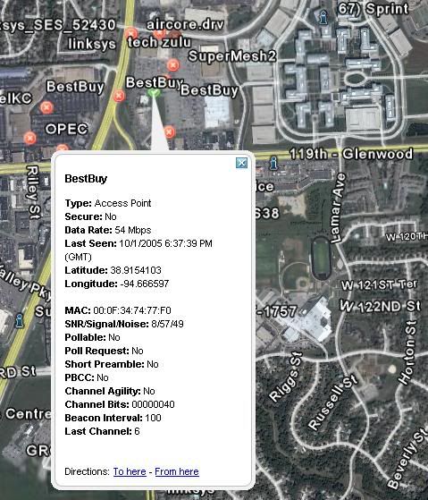
Links:
NetStumbler, tool used for sniffing Wi-Fi, http://www.netstumbler.com
Earth Stumbler, log conversion tool, http://mboffin.com/earthstumbler/
Google Earth, world mapping tool, http://earth.google.com/
--Ryan ¶ 1:30 PM 0 comments
Links:
NetStumbler, tool used for sniffing Wi-Fi, http://www.netstumbler.com
Earth Stumbler, log conversion tool, http://mboffin.com/earthstumbler/
Google Earth, world mapping tool, http://earth.google.com/
--Ryan ¶ 1:30 PM 0 comments
Subscription Options:
 |
 |
 |
||
 |
||||
 |
 |
 |
 |
|
 |
||||
 |
Wi-Fi Technology Forum - Wi-Fi Wireless News, Directory and Forums


